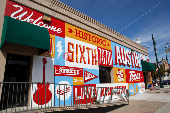
 Street Mural in 6th Street entertainment district [5]
National Register Historic Districts in Austin, Texas
Austin is historically rich and diverse, providing an opportunity to take a step back in time and revisit milestones in politics, urban planning, civil rights, economic development, social justice, culture, and architecture, among other things. The following neighborhoods are prestigiously recognized on the National Register Historic Districts list [1]. These districts are protected and enforce strict standards in design, redevelopment, and maintenance in order to preserve the character and historical social significance of the area.
Austin is historically rich and diverse, providing an opportunity to take a step back in time and revisit milestones in politics, urban planning, civil rights, economic development, social justice, culture, and architecture, among other things. The following neighborhoods are prestigiously recognized on the National Register Historic Districts list [1]. These districts are protected and enforce strict standards in design, redevelopment, and maintenance in order to preserve the character and historical social significance of the area.
- Barton Springs
- Bremond Block
- Camp Mabry
- Clarksville
- Congress Avenue
- Delwood Duplex
- Hyde Park
- Moore’s Crossing
- Old West Austin
- Rainey Street
- Shadow Lawn
- Sixth Street (Pecan Street)
- Swedish Hill
- West Line
- Willow Spence
- Wilshire
- Zilker Park
Hyde parkHyde Park was Austin’s first streetcar suburb, developed by Monroe Martin Shipe in 1891 and intended exclusively for the upper class. Prominent Austin residents built grand, opulent Victorian homes, such as the Oliphent-Walker House [3]. However, due to weak land sales, Hyde Park shifted its marketing towards the working-class and the newly built houses reflected a more modest and affordable architectural style. During the 1920’s-30’s, new housing developments in Hyde Park were less extravagant, instead representing the bungalow style popular at the time [3]. This eclectic mix of residential architecture acts as a timeline covering the growth cycle of this historic neighborhood. Due to resolutions such as the McMansion Ordinance, many of the homes in this area are undesirable for families with children due to the restrictions on redevelopment and building additions. Once an enclave for the working class, Hyde Park is again home to some of Austin’s most wealthy residents.
Today, Hyde Park incorporates two nationally recognized historic districts: Hyde Park Historic District and Shadow Lawn Historic District. Covering over 180 acres of land, this primarily residential area is home to several historical landmarks including the Hyde Park Fire Station[4]. |
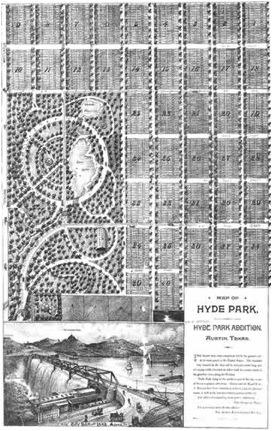
Original map of Shipe's Hyde Park [3]
|
Clarksville
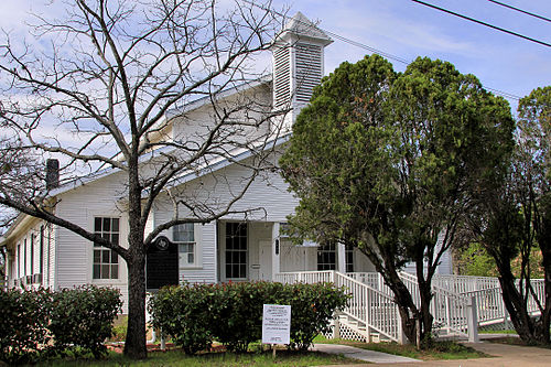 Sweet Home Missionary Baptist Church [7]
Historically, Clarksville was home to the former slave plantation of Governor Elisha Pease. Governor Pease gifted or sold lots of land to freed slaves after emancipation in 1865, leading to the establishment of Clarksville by Charles Clark in 1871. The newly freed slaves established the area with modest homes and the Sweet Home Missionary Baptist Church, a historic landmark that still holds services today. Austin’s first African-American newspaper, the Gold Dollar, also began in Clarksville [2]. The famous "freedom town" is one of only two black national historic districts in America. Although it is designated as a Historic District on the National Register, many of the original buildings and homes in Clarksville are no longer present [6]. When Austin’s 1928 comprehensive plan called for the establishment of a "Negro" district in East Austin, the city attempted to force the predominantly African-American residents of Clarksville to leave the area by cutting off funding and not establishing municipal services and facilities. Even the dirt roads were not paved with asphalt until the Texas Historic Commission designated it as a Historic District in 1975. As Austin's population grew and the area rapidly urbanized, Clarksville became a highly sought after area for land speculators due to its close proximity to downtown Austin. When property taxes increased and pressure from developers intensified, many of the native Clarksville residents were eventually unable to remain in the oldest freedman's town west of the Mississippi [2]. Today, gentrification coupled with rising land values has pushed many of the remaining low-income residents out of the neighborhood. The majority of residential development in Clarksville consists of condos and apartments, which attract student and young professional residents.
Sources
1. "National Register Historic Districts." Official Website of the City of Austin-Planning & Development Review Department. City of Austin, Texas. http://www.austintexas.gov/department/national-register-historic-districts
2. Thompson, Nolan. "Clarksville, TX (Travis County)."Handbook of Texas Online. Texas State Historical Association, 12 June 2010. http://www.tshaonline.org/handbook/online/articles/hpc01
3. "History - Hyde Park." Hyde Park Neighborhood Association. http://www.austinhydepark.org/hyde-park/history-2/
4."Hyde Park Local Historic District." Official Website of the City of Austin-Planning & Development Review Department. City of Austin, Texas. http://www.austintexas.gov/department/hyde-park-local-historic-district.
5. Photo Credit: herronstock.photoshelter.com
6. Emery, Michael. "East Austin Gentrification." Austin Now. KLRU. http://www.klru.org/austinnow/archives/gentrification/
7. Photo Credit: Wikipedia, Clarksville Historic District (Austin,Texas). http://en.wikipedia.org/wiki/Clarksville_Historic_District_(Austin,_Texas)
